


وصف لـ Military GPS
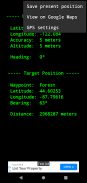
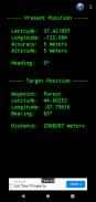
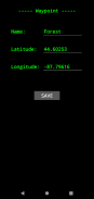
This GPS application uses satellite data and mobile sensors to provide bearing and distance from your present position to your destination. You only need to enter the destination coordinates or save the current position if you want to come back later. It doesn't need a data connection
These are the main features:
- Displays latitude, longitude and altitude using GPS sensor
- Geographic coordinates are expressed in decimal degrees
- Displays the heading based on the Earth's magnetic field, it can be used as a compass (0º=North,90º=East,180º=South,270º=West)
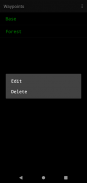
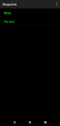
- Can store a target position and display bearing and distance from your present position
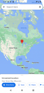
- Can send target position coordinates to Google Maps, allowing sharing with other applications. This option requires internet access
- Works in old devices and uses little battery
- Always will be 100% free
Enjoy ! :-)Diese GPS-Anwendung nutzt Satellitendaten und mobilen Sensoren zu Peilung und Entfernung von Ihrer aktuellen Position zu Ihrem Ziel zu liefern. Sie müssen lediglich die Zielkoordinaten eingeben oder speichern Sie die aktuelle Position, wenn Sie später wieder kommen wollen. Es ist nicht eine Datenverbindung benötigen
Dies sind die wichtigsten Merkmale:
- Zeigt die Breite, Länge und Höhe mit GPS-Sensor
- Geographische Koordinaten in Dezimalgrad
- Zeigt die Überschrift basierend auf das Magnetfeld der Erde, kann es als Kompass verwendet werden (0 ° = Nord, 90 ° = Ost, 180 ° = Süd, 270 ° = West)
- Kann eine Zielposition und Display-Peilung und Entfernung von Ihrer aktuellen Position zu speichern
- Können Zielposition Koordinaten in Google Maps zu senden, so dass den Austausch mit anderen Anwendungen. Diese Option erfordert Internetzugang
- Arbeiten in der alten Geräte und verwendet kleine Batterie
- Immer ist 100% kostenlos
Genießen Sie! :-)
Military GPS - إصدار 3.00
(18-04-2023)Military GPS - معلومات APK
نُسخة APK: 3.00الحزمة: org.z3studio.MilitaryGPSتطبيقات من الفئة نفسها
قد يعجبك أيضًا...


